

Getting to Mendocino and
Getting to The Woodlands - Camp Two
On this page you’ll find an accurate road map of the area.
New and occasional attendees will have a more comfortable time on the road from Mendocino and Fort Bragg to The Mendocino Woodlands using the map below.
About online maps in the wilds of Mendocino County
Many online maps have the gravel and dirt roads in Mendocino State Park labeled incorrectly.
As of 2026 Google has obtained better directions to The Mendocino Woodlands.
Search Google Maps for “Mendocino Woodlands Camp Two” or try this link
https://maps.app.goo.gl/YtzW3id3siDP5XxEA
After you get a few miles outside Mendocino, the mobile signal is sometimes entirely lost. If you intend to try to use online Maps, you’ll find that GPS signal is also spotty. It is recommended to use to use the Google Maps “Offline maps” feature for the area from Mendocino to Fort Bragg and east of Hwy 1 south of Hwy 20 so that it will not fail when you are on the way there. You’ll need to turn on the feature and download the map of the area before you leave home.
Getting To Mendocino
From San Francisco/Santa Rosa to Mendocino: (4-5 hours) Take Hwy 101 North to Hwy 20 in Willits. Turn left [west] onto Hwy 20, take 20 to intersection with Hwy 1. Take Hwy 1 South (turn left) to Mendocino. NOTE: Do not turn off Hwy 20 until you reach the signal light at Hwy 1.
OR
Some people think the safer (and definitely prettier) route is: 101 North to Cloverdale, just north of Cloverdale, take Hwy 128 West. Hwy 128 West ends at Hwy 1. The road merges with Hwy 1 and veers North (right) and takes you into Mendocino without any turns.
From Sacramento to Mendocino: Go North on I-5 to Hwy 20 (near Williams). Go West on Hwy 20 to Hwy 101. Take Hwy 101 North to Cloverdale. Take Hwy 128 West. Hwy 128 ends at the junction with Hwy 1 North (veering to the right), which goes into Mendocino without any turns.
From Eureka area: Take Hwy 101 south to either Hwy 1 or Hwy 20. When you get to Fort Bragg, follow Hwy 1 south to Mendocino.
From Clearlake and Williams area: take Hwy 20 west to Hwy 101. Go north on 101 to Willits, then left (west) on Hwy 20 until it dead ends at Hwy 1. Turn left on Hwy 1 South, proceed to Mendocino.
Public Transportation v. Carpooling: There is NO public transportation to the site. Let’s consider the environmental health of the Woodlands and carpool among friends where possible. You can also request and offer rides on the Elderflower Facebook Community Group page or Contact Us with Subject “Carpool Needed” or “Carpool Offered”.
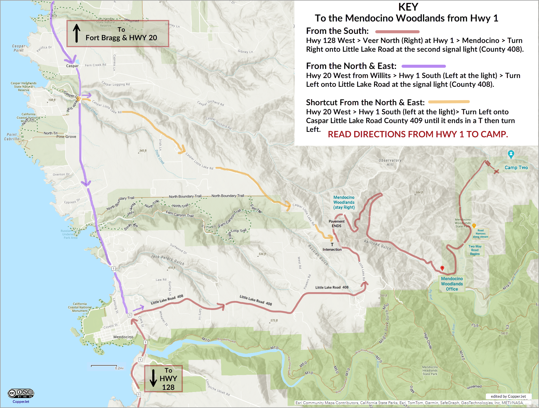
For your convenience, here is a link to a printable PDF of the full size map.
Getting to Camp from Hwy 1 - The Coast Highway
From Mendocino to Camp: (at least 30 minutes) From Hwy 1, turn (East) onto Little Lake Road/County 408, there is a stop light at that intersection. Drive 6.2 miles on the paved road. You will pass a T intersection with County 409 (Caspar Little Lake Road) on the left. The pavement ends about .5 miles after that intersection. Shortly after that look for a “Y” intersection. There is a sign pointing to the Woodlands. See below for Directions from 408 to Camp Two.
Alternate (shorter) Route when coming from the North via Fort Bragg or Hwy 20:
After the intersection and signal at Hwy 20 and Hwy 1, travel South (left) on Hwy 1 for about 2.25 miles. After the Caspar turn off, watch for a short bridge (Caspar Creek) and just after that, you’ll see the sign to County Rd. 409, turn left onto 409 (Caspar Little Lake Road). Then – Follow 409 until it dead ends at Little Lake Road (County Rd 408). Turn Left on 408. After that the directions from 408 to Camp Two are below. (NOTE: If you miss the turn off for 409, just continue travel a few more miles South to Mendocino and turn Left onto County 408 – Little Lake Road. Follow the directions above for directions “From Mendocino to Camp” just above.)
From the intersection of Little Lake Road/408 and Caspar Little Lake Road/409 to the Camp Two:
The pavement ends about .5 miles after the T intersection of 409 and 408. Shortly after that look for a “Y” intersection. There is a sign pointing to the Woodlands, bear right onto the dirt road and drive about 3.3 miles to the entrance to the Woodlands. Be patient – it takes longer than you might think to travel those 3 miles. You’ll see the office on the left and turn in there. From the Woodlands entrance, follow the signs to Camp Two, about 2.8 miles. The road through the campgrounds is a one lane dirt road. Drive very slowly and carefully. There may be campers in Camp One or Camp Three and driving slowly helps keep the dust down. The road before Camp Three narrows due to recent erosion (2024). Camp Two is at the end of the road – after Camp Three. Watch for the Dumpsters on the right. Just after that is a right turn onto a narrow wooden bridge over the creek.
Once you drive past the gate, you can park temporarily in the area in front of the main dining hall/lodge. Look for instructions about parking in the Pre-fest mailing packet on page 6.